


Integrated
Digital Engineering

Land surveying, advanced dimensional control, and intelligent digital twin solutions for the Energy and Infrastructure sectors

SURVEY • LIDAR • DIGITAL TWIN

Strategic Consortium Profile

Geospatial & Survey

LiDAR Technology

Digital Plant Specialists

Alliance Overview

A Strategic Alliance Built for Digital Transformation

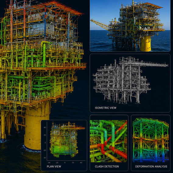
By combining the specialized capabilities of three industry-focused companies, we provide an end-to-end ecosystem for intelligent asset digitization.

We help organizations reduce project risk, improve asset visibility, optimize operational efficiency, and strengthen safety across the entire facility lifecycle.

What We Bring Together

  • Accurate geospatial and survey data acquisition for complex industrial environments.
  • High-precision 3D laser scanning and spatial intelligence for existing facilities and infrastructure.
  • Intelligent modeling, digital twin development, and engineering-ready asset visualization.

Integrated Expertise for Industrial Assets

End-to-End Delivery

Complete workflow from raw survey data to intelligent 3D models and Digital Twin implementation without handoff gaps.

Risk Mitigation

Precise dimensional control and clash-free engineering designs ensure first-time-fit installation and reduced rework.

Operational Efficiency

Reduced engineering time, minimized hot work, and accelerated project schedules through digital accuracy.

Specialized Expertise. Unified Delivery.

Combined Strengths & Capabilities

Our consortium delivers a powerhouse of integrated capabilities, combining decades of land survey expertise with cutting-edge digital engineering and massive project portfolios.

Professionals
0 +
Years of Exp.
0 +
Projects
0 +
Core Sectors
0 +

Core Service Offerings

Integrated Engineering & Digital Solutions

Survey Services

Licensed Land & Engineering Survey

3D Technology

Advanced Capture & Modeling

Digital Solutions

Digital Transformation & Twin

Specialized Services

Niche Engineering Support

The Three Ds Journey

We guide clients through a structured digital maturity journey, transforming physical assets into intelligent digital twins that drive operational excellence.

Icon-1
1

Digitise

Data Capture Phase

3D Laser Scanning (Terrestrial/Mobile)

UAV / Drone Photogrammetry

GNSS & Topographical Survey

Underground Utility Detection (UUDM)

Output: Registered Point Clouds & Raw Data

Icon-2
2

Digitalise

Modeling & Engineering

Intelligent 3D Modeling (PDMS/E3D)

Scan-to-BIM Conversion

Clash Detection & Stress Analysis

2D Drawing Production & MTOs

Output: Intelligent Models & Engineering Specs

Icon-3
3

Transform

Integration & Operations

Digital Twin XR (bOS Platform)

Data & Document Linking (iDrawing AI)

AR / VR / MR Field Collaboration

Live IoT/SCADA Data Integration

Output: Full Lifecycle Asset Management

Let’s Discuss Your Project

Our team of specialists is at your service

Schedule Site Demo