Integrated
Digital Engineering
Land surveying, advanced dimensional control, and intelligent digital twin solutions for the Energy and Infrastructure sectors
Empowering Industrial
Building the Digital Foundation for Smarter Operations
By combining the specialized capabilities of three industry-focused companies, we provide an end-to-end ecosystem for intelligent asset digitization.
We help organizations reduce project risk, improve asset visibility, optimize operational efficiency, and strengthen safety across the entire facility lifecycle.
What We Bring Together
- Accurate geospatial and survey data acquisition for complex industrial environments.
- High-precision 3D laser scanning and spatial intelligence for existing facilities and infrastructure.
- Intelligent modeling, digital twin development, and engineering-ready asset visualization.
Certification & Licenses
Integrated Expertise for Industrial Assets
End-to-End Delivery
Complete workflow from raw survey data to intelligent 3D models and Digital Twin implementation without handoff gaps.
Risk Mitigation
Precise dimensional control and clash-free engineering designs ensure first-time-fit installation and reduced rework.
Operational Efficiency
Reduced engineering time, minimized hot work, and accelerated project schedules through digital accuracy.
Clientele


Specialized Expertise. Unified Delivery.
Combined Strengths & Capabilities
Our consortium delivers a powerhouse of integrated capabilities, combining decades of land survey expertise with cutting-edge digital engineering and massive project portfolios.
Core Service Offerings
Integrated Engineering & Digital Solutions
Survey Services
Licensed Land & Engineering Survey
- Cadastral & Title Survey
- Topographical Survey
- GNSS / GPS Positioning
- Strata Title Subdivision
- Engineering Survey
- Demarcation & Setting Out
3D Technology
Advanced Capture & Modeling
- 3D Laser Scanning
- Scan-to-BIM Conversion
- PDMS / AVEVA E3D Models
- Dimensional Control Survey
- Intelligent 3D Modeling
- As-Built Verification
Digital Solutions
Digital Transformation & Twin
- Digital Twin XR (bOS)
- Data Integration & Linking
- Asset Management Systems
- AR / VR / MR Visualization
- iDrawing AI Extraction
- Remote Collaboration
Specialized Services
Niche Engineering Support
- Underground Utility Detection
- UAV / Drone Inspection
- EPC / EPCC Project Support
- GIS Mapping & Analysis
- Soil Investigation (SI)
- Manpower Supply
The Three Ds Journey
We guide clients through a structured digital maturity journey, transforming physical assets into intelligent digital twins that drive operational excellence.
Digitise
Data Capture Phase
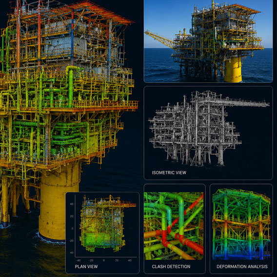
3D Laser Scanning (Terrestrial/Mobile)
UAV / Drone Photogrammetry
GNSS & Topographical Survey
Underground Utility Detection (UUDM)
Output: Registered Point Clouds & Raw Data
Digitalise
Modeling & Engineering
Intelligent 3D Modeling (PDMS/E3D)
Scan-to-BIM Conversion
Clash Detection & Stress Analysis
2D Drawing Production & MTOs
Output: Intelligent Models & Engineering Specs
Transform
Integration & Operations
Digital Twin XR (bOS Platform)
Data & Document Linking (iDrawing AI)
AR / VR / MR Field Collaboration
Live IoT/SCADA Data Integration
Output: Full Lifecycle Asset Management
Let’s Discuss Your Project
Our team of specialists is at your service
- Get tailored guidance for your project needs
- Fast response from our experienced solution specialists
- Find the right solution for your business goals
